Each instance of MSP Challenge is created by loading a configuration file into the MSP Challenge server.
This configuration file is a text file in the JSON format. A separate software tool for editing these configuration files is being developed. Either way, the configuration files stipulate almost everything, e.g. the time frame of the simulation, all the data layers that should be available, which simulations should be running in the background, etc. etc. This means that without a configuration file, there is no MSP Challenge edition or session.
When a configuration file is loaded into the MSP Challenge server, the server pulls all the requests data from the stipulated GeoServer, sets up the MySQL database for the requested edition and all its data. It also sets up the requested background simulations (e.g. Ecosystem simulation (MEL & EwE), Shipping simulation (SEL), Energy simulation (CEL)), and sets up any other more technical things required to get the MSP Challenge edition up and running.
See the North Sea, Baltic Sea, Clyde marine region pages for more information on what the default configuration files for these editions look like. If you've downloaded the entire MSP Challenge simulation platform, feel free to open up one of these configuration files in a text editor of your choice (all .json files in the 'config' directory of the server software are such configuration files) to see what they look like.
How to edit configuration files
General considerations
When you download the client+server you will have also downloaded the configuration file editor. This is a tool we have created to make it easier to edit the configuration files.
If you want to edit an existing configuration file (at the moment: 'NS_basic', 'BS_Basic' or 'CR_Basic'), we highly recommend you make a copy of this file, rename it to something that makes sense to you, and then only edit this new file! You can do this on your windows file explorer or in the config editor by loading the file you want to change and "saving as" before starting to edit.
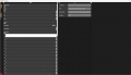
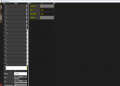
When you open the configuration editor, a pop-up window will open (first image below). There you can select visual options to open the config editor. Once you click on the "Play!" button, you'll see two tabs on the left side (second image below): "Menu" and "Issues". If you click on the "Menu" tab (third image below) and then click on "Load" you can browse and select the file you want to use (the one you just saved). Click on "ok" after selecting your file. The config editor will take a few seconds to load the file you selected.
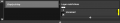
The "issues" tab (fourth image below) is useful when saving your file in case there are any incompatibility in the configuration files, they will be listed here.
File:First config editor screens BB 2.png
General navigation in the configuration editor
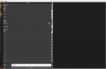
Once your selected file is open, you can see it's structure on the left side (picture below on the right), the main functions in the configuration file are discribed below:
- Restrictions:
Under this category you can define restrictions - combinations of uses that you want to set as impossible (error) or not advised (warning).
- Plans
A configuration file with plans saved in it allows you to recreate a session with those plans again. Use this feature to set up a session with so-called starting plans in them.
- CEL
CEL is the offshore energy simulation. In the config file you can customize the icons shown in the simulation where there are oil and gas fields and wind parks.
- SEL
SEL is the shipping simulation. Here you can configure the ports and the shipping intensity from each port for different time frames.
- MEL
This is an acronym for ‘MSP EwE Link’. MEL allows you to specify which data layers (e.g. fish farms) create which kind of pressures (e.g. artificial habitat) that are subsequently fed into the EwE ecosystem simulation running in the background of an MSP Challenge 2050 session.
- Layers
This category contains all the data layers included and their visualization settings.
- Objectives:
A configuration file with objectives saved in it allows you to recreate a session with those objectives again. Use this feature to set up a session with specific starting objectives in them.
- Region:
At the moment it is not advisable to change the region from the config file as this defines the path to the specific folder the layers and models are stored for this session, all the settings for the session would not make sense anymore (think for instance of layer names that change for different regions).
You might have noticed that some categories on the left have a little arrow under the name, if you click on those it will expand the menu to the right side of the screen (at some point you might need to scrool to the right to see it all), let's see for instance under "restrictions":


Tips to start customizing your session
You might want to start by defining the start year and end year, as well as the duration of each era for your session:

Do not forget to save your changes by clicking on the "Menu" tab and "save as".
Check the objectives set in the basic file and see if you want to add, change (just type on the field you want to change), or remove any of them. To add an objective you may have to scroll down to the end of the list of objectives to click on the + button.
Delete objectives by clicking the x button under it's number. It will delete imediatelly and is not reversable.
Add objectives by clicking on the + button
Add your objectives details


Do not forget to save your changes by clicking on the "Menu" tab and "save as".
You should also customize the restrictions to your needs. There are 3 types of restrictions: info, warning or error. Each has a different consequence in the game, all involve at least a message under the Issues tab of a plan. Errors hamper players to finalize a plan, warnings are strong messages but players can still finalize a plan, and info messages are purely insightful information messages. Adding, changing and removing restrictions follows the same logic from the objectives, if you want to add an objective, scrool to the end of the objectives list and click on the + button (just like for objectives). Follow the steps to add a new restrictions in the image gallery below.

Click on the downside arrow

Click on the + button
Click on the side arrow
Right click on the "Message" field
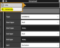
Click on "Instantiate" to be able to add text
Type the message you want to display when this restriction is triggered, the type of restriction you want to set, and the 2 layers you want to select to set the restriction.


Do not forget to save your changes by clicking on the "Menu" tab and "save as".
You can also customize the data layers present in the platform, removing and changing the way they are visualized in the platform itself. Is also allows you to add new data layers based on e.g. GIS data from your GeoServer. Every data layer has its own variables, e.g. the geotype, category it should fall under (points, lines or polygons), whether it should be editable by players or not, etc. You can also set e.g. the names and colors of each type under each data layer here.
Do not forget to save your changes by clicking on the "Menu" tab and "save as".
You should see a confirmation message at the top of your screen. • If you then go back to your MSP Challenge 2050 main server page (http://localhost/stable/api/visual/start) you can select your new, updated configuration file, and click ‘Reload Database’ to thus set up your MSP Challenge 2050 server and session.
Plans:
Here you can simply click on the Export Plans button to retrieve the plans that are currently in the database (because you and/or your players drew them in the game) and save them to the configuration file.
MEL
The window shows each data layer connected to each pressure. Per pressure, you can add layers or remove them. The checkbox before a data layer indicates whether the layer introduces said pressure already during the construction phase (checked) or not (unchecked). The decimal number shown behind each data layer in each pressure (always between 0 and 1) are factors. The higher this number, the higher the impact said data layer has on said pressure.
Extra tips
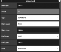
If you find yourself not being able to edit a field, right click on it, you will be presented with 2 extra options: "info" and "instantiate". The "info" button will provide you insight over the field you are editing, if you click on the "instantiate" button you will enable editing the text.
If you are not sure about what a field name means or what values should be filled in in a field, you can right click with the mouse and click on "info" to have more information. Note that we are still implementing this feature so it's possible that when you right click on a field nothing shows up yet.
 Co-funded by the European Union.