Showing below up to 50 results in range #101 to #150.
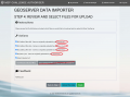 Geoimport step 4 2.png 1,455 × 1,074; 253 KB
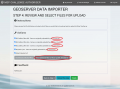 Geoimport step 4 BUas Server.png 1,455 × 1,074; 256 KB
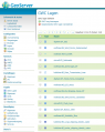 Geoserver.png 681 × 856; 77 KB
 Geoserver add web feature server.png 1,363 × 493; 93 KB
 Geoserver add wms cascade.png 1,013 × 555; 62 KB
 Geoserver wms layer crs.png 1,184 × 1,124; 68 KB
 Gillnet-500.png 500 × 350; 107 KB
 Grabber scoop polygon pattern.png 64 × 64; 4 KB
 Gradient options.png 480 × 360; 12 KB
 Green.pdf ; 194 KB
 Harald Warmelink.jpg 1,577 × 1,577; 255 KB
 Helcom.PNG 232 × 223; 18 KB
 INFO Restriction Indicator.png 49 × 55; 2 KB
 Icon.png 82 × 82; 5 KB
 IconOil.png 81 × 81; 6 KB
 Iconboat.png 79 × 82; 8 KB
 Icond.png 86 × 86; 8 KB
 Icondirection.png 66 × 66; 4 KB
 Icondot.png 67 × 68; 3 KB
 Icondredge.png 85 × 86; 4 KB
 Iconfish.png 91 × 91; 5 KB
 Iconinfo.png 82 × 83; 5 KB
 Iconlighthouse.png 86 × 85; 3 KB
 Iconlightning.png 84 × 85; 3 KB
 Iconoilrig.png 84 × 84; 3 KB
 Iconoilrigclosed.png 86 × 85; 11 KB
 Iconport.png 84 × 85; 5 KB
 Iconship.png 85 × 82; 2 KB
 Iconsocket.png 81 × 85; 2 KB
 Iconsurfing.png 84 × 84; 5 KB
 Icontransformer.png 86 × 82; 5 KB
 Iconwalking.png 76 × 77; 6 KB
 Iconwreck.png 86 × 81; 7 KB
 Iliad Logo Colour V1.0.png 1,080 × 351; 57 KB
 Image-2024-2-5 15-48-21.png 1,344 × 1,115; 76 KB
 Image-2024-2-6 16-52-59.png 1,346 × 830; 47 KB
 Image.png 524 × 317; 65 KB
 ImageAnalyseDataLayers.png 1,416 × 1,097; 1.33 MB
 ImageDatalayers.png 724 × 1,121; 801 KB
 ImageDigDeeperTryAgain.png 1,334 × 914; 866 KB
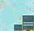 ImageDrawPlans.png 1,420 × 1,300; 1.06 MB
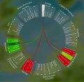 ImageExploreConsequences.png 1,358 × 1,327; 1.45 MB
 ImageServerManager.png 1,425 × 819; 161 KB
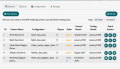
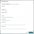 ImageServerManagerAddSession.png 1,214 × 1,209; 141 KB
 ImageShareCollaborate.png 1,216 × 638; 741 KB
 ImageSimulateEvaluate.png 1,966 × 736; 1.63 MB
 Image 5.png 140 × 139; 707 bytes
 Imaged.png 92 × 91; 9 KB
 Imagedbda.png 84 × 84; 6 KB


 Co-funded by the European Union.