No edit summary |
No edit summary |
||
| Line 10: | Line 10: | ||
|- | |- | ||
| class="content separator" valign="top" | | | class="content separator" valign="top" |[[File:Plan Wizard.png|center|alt=|frameless]] | ||
[[File:Plan Wizard.png|center|alt=|frameless]] | |||
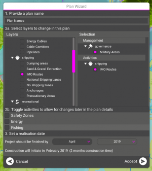
Use the '''Plan Wizard''' to create new spatial plans where multiple layers can be added, and the date of implementation can be changed to stack multiple plans for cumulative effects. | Use the '''Plan Wizard''' to create new spatial plans where multiple layers can be added, and the date of implementation can be changed to stack multiple plans for cumulative effects. | ||
| class="content separator" valign="top" | | | class="content separator" valign="top" |[[File:Edit Geometry.png|center|alt=|frameless]]Within the '''selected layers''', the user is able to '''edit, remove,''' or '''add''' data, separating layers into types of varying purpose. | ||
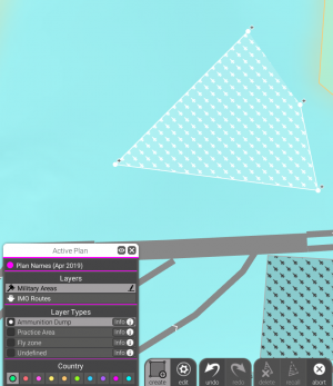
[[File:Edit Geometry.png|center|alt=|frameless]]Within the '''selected layers''', the user is able to '''edit, remove,''' or '''add''' data, separating layers into types of varying purpose. | |||
|}<br /> | |||
====Collaborate with other players==== | ====Collaborate with other players==== | ||
{| width="100%" | {| width="100%" | ||
| Line 31: | Line 28: | ||
| class="content separator" valign="top" |Players can select their country of choice, allowing multiple players to take control and develop plans for a single country or region. | | class="content separator" valign="top" |Players can select their country of choice, allowing multiple players to take control and develop plans for a single country or region. | ||
|} | |}<br /> | ||
====Implement (Collaborative) spatial plans==== | ====Implement (Collaborative) spatial plans==== | ||
{| width="100%" | {| width="100%" | ||
| Line 39: | Line 36: | ||
|- | |- | ||
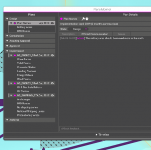
| class="content separator" valign="top" | | | class="content separator" valign="top" |[[File:Plan Monitor.png|center|frameless|355.994x355.994px]] | ||
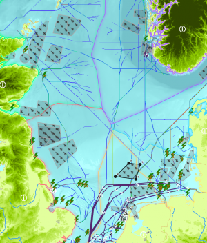
| class="content separator" valign="top" | | | class="content separator" valign="top" |[[File:NS Overview.png|center|frameless]] | ||
|} | |}<br /> | ||
====Simulate effects of spatial plans==== | ====Simulate effects of spatial plans==== | ||
{| width="100%" | {| width="100%" | ||
| Line 51: | Line 48: | ||
|- | |- | ||
| class="content separator" valign="top" | | | class="content separator" valign="top" |[[File:Shipping Clear.png|center|frameless]] | ||
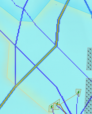
Thee simulation platforms, calculating '''Ship Traffic, Energy Production Capacity,''' and '''Ecosystem Dynamics''' are connected to the sea basins, measuring cumulative impacts throughout the area. Models calculate the latest state every '''month''' of '''in game time''', creating a continuous simulation of the current state of the sea basin. | Thee simulation platforms, calculating '''Ship Traffic, Energy Production Capacity,''' and '''Ecosystem Dynamics''' are connected to the sea basins, measuring cumulative impacts throughout the area. Models calculate the latest state every '''month''' of '''in game time''', creating a continuous simulation of the current state of the sea basin. | ||
| class="content separator" valign="top" |'''Plans''' developed and implemented by the users generate layertype dependent levels of '''impact''' on the '''simulation''' models. Every change matters and '''alters''' the state of the '''sea basin''', be it on the ecology, ship intensity, or energy production. | | class="content separator" valign="top" |'''Plans''' developed and implemented by the users generate layertype dependent levels of '''impact''' on the '''simulation''' models. Every change matters and '''alters''' the state of the '''sea basin''', be it on the ecology, ship intensity, or energy production. | ||
|} | |}<br /> | ||
====Review & evaluate key objectives of targets==== | ====Review & evaluate key objectives of targets==== | ||
{| width="100%" | {| width="100%" | ||
| Line 69: | Line 67: | ||
| class="content separator" valign="top" | | | class="content separator" valign="top" | | ||
|} | |}<br /> | ||
==Server== | ==Server== | ||
Revision as of 15:11, 6 February 2020
Client
Draw spatial plans
Utilize data from GIS sources such as EMODnet or Copernicus to draw spatial plans to edit, remove, or add data on layers from varying human activities.
| Create Plans | Draw Geometry |
|---|---|
|
Use the Plan Wizard to create new spatial plans where multiple layers can be added, and the date of implementation can be changed to stack multiple plans for cumulative effects. |
Within the selected layers, the user is able to edit, remove, or add data, separating layers into types of varying purpose. |
Collaborate with other players
| Up to 20 users | Play as Multiple Countries |
|---|---|
|
Connect to a single sea basin wit up to 20 individual computers to collaborate in the spatial development of your sea basin. |
Players can select their country of choice, allowing multiple players to take control and develop plans for a single country or region. |
Implement (Collaborative) spatial plans
| See, comment, and approve plans | Impact whole sea basins |
|---|---|
Simulate effects of spatial plans
| Simulation platforms | Impacted by the users |
|---|---|
|
|
Plans developed and implemented by the users generate layertype dependent levels of impact on the simulation models. Every change matters and alters the state of the sea basin, be it on the ecology, ship intensity, or energy production. |
Review & evaluate key objectives of targets
| Up to 20 users | See, comment, and approve plans |
|---|---|
Server
_old
- Integrate and review dozens of data layers from relevant external GIS sources such as EMODnet or Copernicus.
- Draw up spatial plans for human activities and marine protection in a particular marine region, notably the North Sea, Baltic Sea or Clyde marine region.
- Collaborate with other players/users to define and refine your spatial plans before implementing them.
- Have a new (collaborative) spatial plan implemented besides or instead of existing plans and activities in the marine region.
- Simulate the effects of spatial plans for the marine region's energy production capacity, ship traffic, and ecosystem dynamics.
- Review and evaluate key objectives or targets for the marine region with your spatial plans.
To fully understand what the above means, have a look at our video tutorials, or simply try out our online demo.
 Co-funded by the European Union.