Wilcoboode (talk | contribs) No edit summary |
No edit summary |
||
| (54 intermediate revisions by 2 users not shown) | |||
| Line 1: | Line 1: | ||
On this page you can find | On this page you can find information on how to learn how the MSP Challenge Simulation Platform works. | ||
Since version 4.0-RC1, there's a Tutorial mode included in the game software. You can find it by logging on to a session, and then opening up the main menu by clicking on the cog wheel in the top-left corner: | |||
[[File:Settings button.png|left|thumb]] | |||
[[File:Main menu.png|thumb|center]]The Tutorial button will activate the tutorial, consisting of the following: | |||
# The basics of navigating over the map and the more general buttons on the left. | |||
# Finding, activating, and understanding all the data layers at your disposal. | |||
# Creating a spatial plan, in which you designate areas for protection and/or certain human activities. | |||
# Analysing consequences of all the spatial plans to e.g. the ecosystem, once the simulations calculating those consequences have actually run. | |||
Latest revision as of 09:40, 3 April 2023
On this page you can find information on how to learn how the MSP Challenge Simulation Platform works.
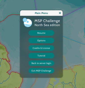
Since version 4.0-RC1, there's a Tutorial mode included in the game software. You can find it by logging on to a session, and then opening up the main menu by clicking on the cog wheel in the top-left corner:
The Tutorial button will activate the tutorial, consisting of the following:
- The basics of navigating over the map and the more general buttons on the left.
- Finding, activating, and understanding all the data layers at your disposal.
- Creating a spatial plan, in which you designate areas for protection and/or certain human activities.
- Analysing consequences of all the spatial plans to e.g. the ecosystem, once the simulations calculating those consequences have actually run.
This page was last edited on 3 April 2023, at 09:40. Content is available under GPLv3 unless otherwise noted.


 Co-funded by the European Union.